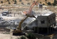
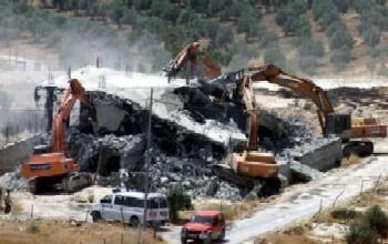
‘Caterpillar did it again!’ I thought looking at a picture of the latest home demolition of Palestinian homes. This morning, Amer, a colleage, walked quickly down the stairs of the office. ‘I have to run,’ he said, ‘there is another home demolition’. ‘Where? In Sur Baher’.

Mahfouz AbuTurk/Reuters
The owners of the homes and land have tried to obtain construction permits but were denied over and over again. Sur Baher is surrounded by the Israeli colonies of Armon Henatsif, ‘Har Homa’ from the south, and Talpiot from the west.

Mahfouz AbuTurk/Reuters
Looking at the picture, I’m reminded that it has been Caterpillar’s bulldozers and other equipment that are being used in the demolition of Palestinian homes.
Between 1987 and 2001 about 350 Palestinian homes were demolished in the city. The numbers for the whole Occupied Palestian Territories are much higher. In many cases Caterpillar’s equipment has been used to demolish these homes.
While about 350 Palestinian houses were demolished in Jerusalem between 1987 and 2001, in West Jerusalem some demolition orders were carried out, but only of an extra room or a porch, never a whole building like in Palestinian neighbourhoods. However, it is estimated that 84 percent of the building violations take place in the Jewish sector. While Palestinians are responsible for sixteen percent of the building violations, more than 60 percent of the demolitions are carried out on Palestinian houses.
Sur Baher has been targeted under the disguise of zoning. Forty percent of the land in occupied East Jerusalem is zoned ‘Green area’, which is land set aside to be preserved for environmental or recreational purposes. However, this is a zoning technique to prevent the land being used by Palestinian owners and to hold the land as a reserve for housing settlers. The colony ‘Har Homa’ built on expropriated Palestinian land on Jabel Abu Ghneim is an example of this technique. The land was initially defined as ‘Green area’ to prevent the neighboring Palestinian villages of Sur Baher and Um Tuba to expand. Jabal Abu Ghneim was subsequently rezoned for residential construction of the new Israeli colony of ‘Har Homa’.
Sur Baher straddles the the armistice border drawn up after Israel’s occupation war in 1967. Its residents are considered Jerusalem residents. For a long time, Sur Baher has been a target in the West Jerusalem Municipality’s home demolition campaign, designed to minimise and transfer the indigenous population to make room for Israeli settlers. After the election of the former Likud administration this campaign was intensified. Despite the fact that these families are considered Jerusalemites and pay Jerusalem municipal taxes, they have been frequently subjected to home demolitions.

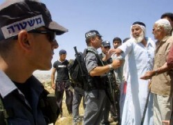
AP Photo/ZOOM 77
In August 1970, 14,000 dunums were expropriated from Malha, Sur Baher and Beit Jala in the south of Jerusalem. Part of this land was used for the building of Gilo and East Talpiot colonies. In April 1991, 2,000 dunums were seized from Umm Tuba, Sur Baher and Beit Sahur, for the ‘Har Homa’ colony, built on confiscated land on Jabel Abu Ghneim. This area lies southeast of Jerusalem. It is the highest point within the surrounding area where it overlooks the cities of Jerusalem, Bethlehem, and Beit-Sahour and the villages of Um-Tuba and Sur-Baher. Jabal Abu Ghneim used to provide the only area for the natural growth of the Bethlehem, Beit Sahour, Um Touba and Sur Baher communities, communities that have long suffered from conditions of extreme overcrowding as a result of the confiscation of land on Jabel Abu Ghneim.
In September 2000, Sur Baher became subject of another expropriation campaign. The West Jerusalem municipality gave its final approval for the so-called “eastern ring road”, a by-pass road connecting the Jewish settlements located east of Jerusalem. The road will cover 1,070 dunums of Palestinian land and will stretch from Beit Safafa in the south of Jerusalem, via Sur Baher, Umm Tuba, Wadi Nar and Abu Dis, to the Mount of Olives. The road will include 2 tunnels, one under the Mount of Olives and one west of Abu Dis, and a number of bridges.


