Challenge 12 January 2004

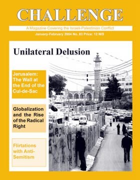
Cover of the January-February edition of Challenge magazine. Click to visit the site.
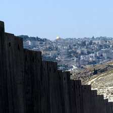
Today the Al Eizarya road comes to a sudden halt at a wall two meters high, topped by rolls of barbed wire. What was once a major artery has become a parking lot for service cabs. If you want to get to Jerusalem, you must turn around, drive east to a checkpoint (not shown on the map) at the settlement of Ma’ale Adumim, turn around again and head northwest to the A Zaim checkpoint, then to French Hill… and finally to East Jerusalem. The expedition goes on for an hour or more.
Even if you take this approach, however, your arrival in Jerusalem – supposing you’re a Palestinian – depends on additional factors. First, the checkpoints: the soldiers don’t always let Palestinians through. Second, anyone seeking to enter Jerusalem must have a blue identity card (“Jerusalemite”) and not a green one (“West Banker”). This measure rules out half the people of East Sawahre and the vast majority of those from Abu Dis. These may enter only by a special permit, rarely granted.
In its present two-meter-high version, the wall is jumpable. Here the Jerusalemites have an advantage. If a Palestinian jumps from Jerusalem toward the West Bank and a soldier catches him, a blue ID will save his neck. If the ID is green, however, and he’s caught jumping either way, his next stop will be the Cliff Hotel in Abu Dis, now a prison.
In any case, such infiltration is temporary. Israel intends to replace the two-meter wall with another one eight meters high. It is also planning a fence to enclose the three villages on the east as well. That will cage them in on all sides but the south. They will be cut off from their natural metropolitan region, Jerusalem, as well as from points east (Jericho, the Dead Sea, Jordan) – except by permit under special conditions, still unknown. If Israel does not block egress to the south as well, their only passage to a wider world will be by back roads through the desert fringe to Bethlehem (which will also be behind the barrier). Given the present checkpoints at A Zaim and Ma’ale Adumim, these 100,000 people already feel like inmates.
Security?
The barrier looks like it’s meant for security. In open areas, it is 50 yards wide, consisting of barbed wire, an anti-vehicle ditch, a dirt path to pick up footprints, an electric fence, another dirt path, an asphalt road, yet another dirt path, and more barbed wire. In built-up areas, it becomes a wall eight meters high.
If the barrier is intended for security, however, its course is very odd. It does not separate Jews from Arabs, or Arab villages from settlements. It separates Arabs from Arabs. It includes about 60,000 West Bank Palestinians who are not Jerusalem residents, while fencing out 26,000 of the 230,000 who are. Jerusalem residents can travel anywhere in Israel. Several bombings have been their work. As long as Israel insists on keeping Arab Jerusalem inside, it is hard to see how the barrier can make a significant difference. By creating more bitterness, it will likely increase the attacks. Furthermore, it won’t stop Palestinians beyond the fence from shooting, as they have frequently done against the neighborhood (settlement) of Gilo.
If the purpose is not security, what then?
By nipping off pieces beyond the municipal border, the wall continues the policy of annexation begun in 1967. Until the June war of that year, Arab Jerusalem amounted to a modest 6000 dunams (1500 acres), which comprised the Old City and several neighborhoods. On the war’s last day, the Knesset decided to annex it along with another 64,000 dunams. The guiding principle was this: as much land and as few Arabs as possible. Israel annexed the refugee camp in Shuafat (it isn’t including the camp within the new wall), Jabal Mukabir, parts of Al Eizarya, parts of Abu Dis, parts of Beit Hanina, and parts of a dozen other West Bank villages. “Jerusalem”, thus enlarged, stretched from the fringe of Bethlehem to that of Ramallah. It divided the West Bank into separate cantons, north and south.
Jerusalem had always played an essential role in the lives of the villages surrounding it, whether or not these became part of the city after 1967. It has the commercial centers, hospitals, universities, government agencies, news agencies, and of course the holy places. It supplied the villages not only with goods and services, but also with 60% of their jobs.
The wall cuts through all that. Take, for example, the tribe of Arab al-Sawahre. Some of its members live in Jabal Mukabir, which was annexed to Jerusalem and is inside the new barrier. But others live in East Sawahre and Sheikh Sa’ad, which were not annexed and will be fenced outside. In pre-barrier times the tribal members could visit one another without impediment. There was marriage, friendship, commerce – all the relationships that go to make up a human life. As a result of marriages, half the tribal members wound up with blue ID’s and the rest with green. Now comes the barrier, dividing blues and greens on one side from blues and greens on the other, separating the store from its customers, the farmer from his lands, the pupils from their school, the sick from the hospital, the dead from the cemetery.
Nasser Abidat (green ID), a member of East Sawahre’s Committee Opposing the Fence, describes his own situation: “My whole family lives in Jabal Mukabir, and ever since the fence was built I haven’t been able to see them. I have a twenty-year-old son taller and heavier than me. He needed urgent treatment at Muqassed. I had to carry him on my back for hours over goat tracks to get him to the hospital. People with money can hire an ambulance for 350 shekels to drive through the checkpoints. As for women in labor, whoever has the money calls an ambulance. Whoever doesn’t, God help her!”
The service cabs, which ferry people between the checkpoints, multiply with the growth of the fence. The academic level of their drivers too is on the rise: most today have college degrees.
Jamal Ja’fer of Sawahre, a member of the secretariat in the Jerusalem branch of the Association of Trade Unions, points to a checkpoint erected by the army on the road that once joined Sawahre to Jabal Mukabir: “Even when you’re dead the wall blocks your way. Our cemetery is in Jabal Mukabir, west of the fence. When someone dies, we drive the body to the checkpoint, then carry him on foot to the other side and there transfer him to a car that takes him to his final resting place.
“Some 380 pupils,” he continues, “have to travel this Via Dolorosa every day: they live in Sawahre but study in Jabal Mukabir. A bus takes them to the checkpoint, they cross 250 meters on foot, and another bus picks them up. How we’ll manage in winter is anyone’s guess.”
For those not allowed into Jerusalem, Wadi Nar, a winding, hazardous, desert road, has borne the traffic between the southern and northern West Bank for the last ten years. Wadi Nar too was closed in the recent sealing of villages. Wherever you go today in the areas outside the fence, you see Palestinians on foot: women carrying babies, workers seeking jobs, pupils trying to reach their schools, whole families in fancy dress on their way to weddings or funerals… they follow the goat paths over the hills, skirting the checkpoints.
A Blind Policy
Security, as said, is a pretext. The barrier establishes the new border intended for Jerusalem. Its purpose is to isolate the surrounding Palestinian villages, cutting them off from each other, and strengthen the Israeli settlements, creating continuity between them. It will prevent the establishment of Jerusalem as the Palestinian capital. Dividing Abu Dis, it also squelches an idea, once floated, to count this village as part of Jerusalem and place the Palestinian capital there.
The broader aim is to prevent the possibility of a normal Palestinian state or, for that matter, a normal Palestinian life. Throughout the country, the barrier attaches broad stretches to Israel. It outlines the map of “greater Israel,” with enclaves (read “prisons”) for the Palestinians. Not by chance do they call the fence their “third naqba, catastrophe” (after 1948 and 1967).
The barrier has become, in addition, an essential component of Prime Minister Ariel Sharon’s latest threat: a unilateral Israeli pullback to the borders he intends to make permanent, which would leave the Palestinians with a mere 40% of the West Bank. The fence thus symbolizes the cessation of efforts to achieve a negotiated agreement.
When South Africa’s apartheid regime enclosed the blacks in Bantustans, the world applied sanctions until it fell. Israel is using the barrier to create a map along racist lines, ghettoizing the Palestinians. The world protests, but it seems unlikely that the West, especially America, will ever reach the point of sanctions against its most reliable foothold in the Middle East.
The inhuman conditions imposed by Israel will breed, nonetheless, more revolt. They will undermine the credibility of the Occupation – not only in the world, but within the Jewish State itself. After 36 years of Occupation, Israel has reached a cul-de-sac, and there it builds a wall.
The above article first appeared in the bimonthly Israeli alternative news magazine Challenge. Annual subscriptions are available for $35 (US), 30 EU, £20 (UK) or 75 NIS (Israel and Palestine).

